Friday, March 29, 2013

Lake of the Clouds, Porcupine Mountains - Michigan's U.P.

Lake of the Clouds is a lake in the Porcupine Mountains in the Upper Peninsula of Michigan that sits in a valley and is surrounded by trees. You can see Lake of the Clouds from different vantage points. The easiest way to see it is from an overlook that is very accessible from a really nice boardwalk. This is how we saw Lake of the Clouds the first two times that we visited the Porkies. The picture below was taken from the overlook.

photo by mrbturner

The third time that we went to the Lake of the Clouds, we hiked the Escarpment Trail. In my opinion, this 4 mile trail is the best hike in the Porcupine Mountains. The sheer cliffs and the view of the lake far below are definitely worth the work it takes to make it up (or down) the frequently steep trail.

www-personal.umich.edu

The best time to see many places in the U.P. is in the Fall. Lake of the Clouds is no exception. It is an absolutely amazing sight once the leaves on the trees have changed colors.


photo by dturner

photo by mrbturner

I am always surprised when I go to the U.P. that it's never crowded. In fact, my wife and I have hiked many times for several hours without seeing another person. I remember a conversation that we had when we were staying at a resort near the Porcupine Mountains. We were sitting in some lawn chairs at the edge of Lake Superior. I looked around and said to my wife, "It's kind of crowded here." She just laughed. I said, "What?" She said, "There are six other people here..." I guess I had gotten a little used to having the U.P. all to myself.

photo by mrbturner

Check out my blog's Facebook page - Amazing-Places

Sunday, March 24, 2013

Presque Isle River, Porcupine Mountains - Michigan's U.P.

photo by dturner

I love Michigan's Upper Peninsula - especially the Porcupine Mountains. One of my favorite things to do in the Porkies is hike along the Presque Isle River down to Lake Superior. There is a boardwalk on the west side of the river that makes the hike accessible to just about anyone...as long as you don't mind stairs. If you follow the boardwalk upstream, you will be able to see two different waterfalls. Manabezho Falls, pictured below, and Manido Falls.

photo by mrbturner

Once you have hiked to Manido Falls, you have come to the end of the boardwalk. This is a great place to take a break and catch your breath. If you hike back downstream toward Lake Superior, the many stairs will eventually lead you to a suspension bridge that spans the river. From the bridge, you can see an amazing unnamed falls. It is in this spot that you can see what is, in my opinion, the coolest thing about the Presque Isle River. The fast moving, spinning action of the water has carved the most unique whirlpool shapes into the stone of the river bank.

photo by mrbturner

photo by dturner

Once you cross over the suspension bridge, you can hike on the unpaved trail through the woods to Lake Superior. The beach is covered with rocks of all different colors. It's a great place to picnic and take in the beauty that is Lake Superior. Don't forget to look for agates while you're there too.

photo by dturner

I've been to the Presque Isle River several times, and every time I go I see something interesting that I hadn't noticed before. It's an amazing place to go to enjoy nature, hike to some really awesome waterfalls, and see Lake Superior.


Sunday, March 17, 2013

Bryce Canyon National Park, Utah

Bryce Canyon National Park in southern Utah is undeniably one of the coolest places I have ever been. It's a geological wonder and the only place in the world where you will see anything like it. Frost, ice, and rain have shaped the sandstone of Bryce Canyon into really interesting shapes called "hoodoos."

photo by mrbturner

Hoodoos are tall rock spires of varying thickness and heights. Some hoodoos in Bryce Canyon are a little taller than the average person, and others are about one hundred feet tall.

photo by mrbturner

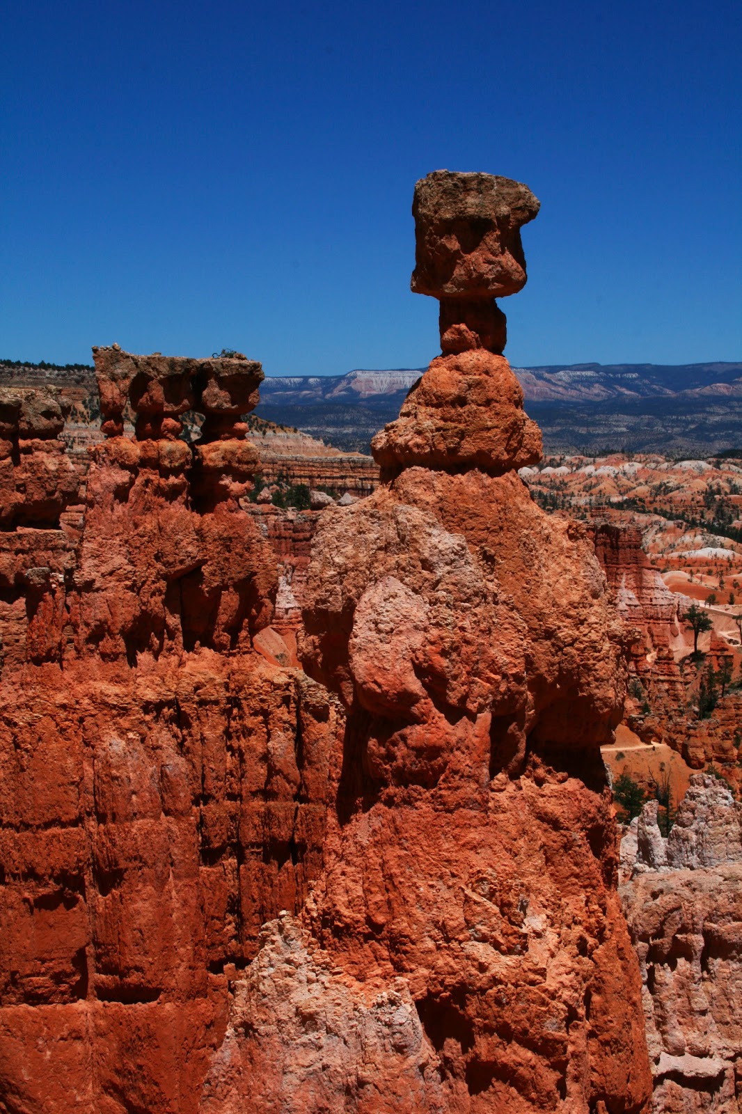
The most famous hoodoo in Bryce Canyon is probably Thor's Hammer. This hoodoo, pictured below, is 150 feet tall and very impressive.

photo by mrbturner


We spent six days in Bryce Canyon. We went on some really great hikes and took some really awesome pictures. My favorite hike was the 8.2 mile Fairyland Loop. My father-in-law and I hiked this strenuous hike in about 4 hours. There weren't a lot of people on this trail, so it was really peaceful and quiet.


photo by mrbturner


photo by dturner

My most favorite thing about Bryce Canyon, though, is not what you can see during the day. It's what you can see at night that is most fascinating. Bryce Canyon's sky is one of the darkest in the country. The high elevation, clean and dry air, and very little light pollution make Bryce one of the best places to see the stars. Some say that Bryce is the last grand sanctuary of natural darkness.

We were there during the new moon phase, so the sky was really dark. One night we went to a ranger talk about the night sky and were fortunate enough to be able to look through four huge telescopes. We saw Mars, Saturn, a globular cluster, and a twin star. We took a night hike and sat near Thor's Hammer for over an hour trying to get a good picture. We aren't very well equipped for night sky photography but decided that we would try anyway. We didn't get the shot that we were looking for, but we had fun trying, and there's always next time! Here's an image that I found online.

nightscapephotos.com

I would recommend Bryce Canyon National Park to anyone who enjoys hiking and camping. Even though we got to see most of the park and hike on several trails, I will definitely go back there. The geology is unlike anything you will see anywhere else.


Saturday, March 9, 2013

Antelope Canyon, Page Arizona

Upper Antelope Canyon - Page, AZ
The Antelope Slot Canyon in Page, Arizona is truly a marvel of nature. It is definitely one of the most amazing things I have ever seen. It's a slot canyon located on the Navajo Indian Reservation near Page, Arizona. There are actually two different slot canyons on the reservation, Upper Antelope Canyon and Lower Antelope Canyon. We took a tour of Upper Antelope Canyon while we were on vacation last summer.

photo by s.cook

Antelope Canyon was formed from water erosion due to flash flooding. Sand particles that are carried in the wind also account for some of the erosion over time. The result is a slot canyon that you can walk through. The walls are smooth and form really impressive flowing shapes in the stone.

photo by s.cook

The only way that you can see Antelope Canyon is by guided tour. Tours to the canyons run several times a day. There are a few tour companies to choose from. We bought our tour directly on the reservation. Our tour guide's name was Henry, a Navajo native. He was a great guide who helped show us great spots to take pictures and shared with us some Navajo history as we walked through Antelope Canyon. We went during midday so that the sun would be high in the sky. This makes for some pretty impressive beams of light in the canyon.

photo by mrbturner
Antelope Canyon is truly a photographer's dream. I will definitely go back and tour Lower Antelope Canyon. It's hard to believe that before seeing my first slot canyon I never knew that such a thing existed. It's a pretty amazing experience.

photo by dturner

Most people have heard of orbs before. To many people, orbs are known to be circular artifacts that show up in pictures in which a flash is used. But what about when an orb shows up in a picture in which NO flash was used? How about the same orb showing up in three different pictures taken by three different people on the same day at almost the exact same moment? Some people believe that orbs are more than just artifacts in a picture. Some believe that orbs are spirits or energy sources. The following three pictures were taken at the entrance to the Upper Antelope Canyon. The first one was taken by my wife, the second one by my father-in-law, and the third one by me. Notice the large orb in each picture in almost the exact same location.

photo by dturner

photo by s.cook

photo by mrbturner

What do you think?

Sunday, March 3, 2013

Canyon Overlook - Zion National Park

By now you know that Zion National Park is one of the most amazing places that I have ever been to. There are so many things about Zion that I could write about. It is really hard to pick out just a few to put on my blog. The last place in Zion that I want to talk about is the Canyon Overlook Trail. We did this hike on our first evening in Zion. It's a pretty easy hike, and the view from the top is really incredible. We watched the sun go down and the moon rise. It was a great way to end our first day.


photo by mrbturner
 When you get to the top of Canyon Overlook, you are standing on the very top of the above structure. Notice the natural arch in the picture. This picture is taken from the road right before going though the Mt. Carmel Tunnel.

photo by dturner
 Of course, there were many opportunities for great pictures on the Canyon Overlook trail.


photo by dturner


photo by mrbturner


photo by dturner


photo by dturner
It was fun to climb to the top of this rock and get some fun pictures as the moon was rising.